

Map scale is the reduction ratio we use when transferring a map or plan of a place from real life to plane.
There are 3 types, in fact, they all say the same thing, but in different ways.
Let’s dive in,
The reduction ratio is a scale expressed in fractional numbers. Such as 1/500, 1/5.000, 1/50.000, and 1/500.000. The numerator is always 1 in fractional scales. The number in the denominator shows how many times the mapped area has been reduced. For example 1: 3000 shows that 1 unit on the map equals 3000 units on the earth’s surface

A linear scale is a line divided into equal parts. It is used in maps to show the relationship between a specific distance on the map and the actual distance on earth.
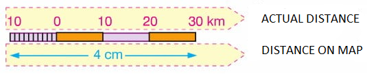
A given scale tells you exactly how much distance is represented by 1 cm.

As you can see Map Scale is that simple to understand.
You can also read ” Understanding Map Projections in 5 Steps “


