
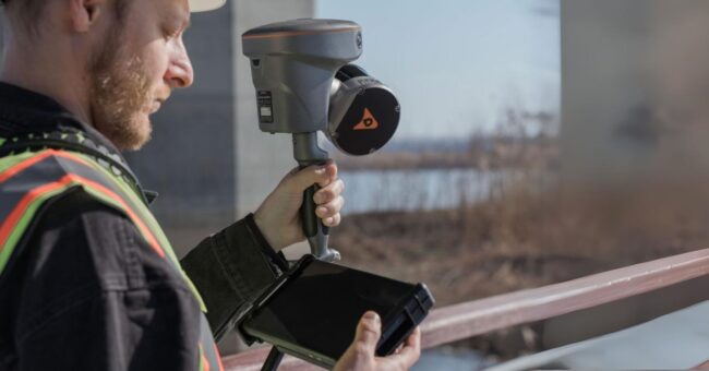
CHC Navigation has introduced the RS10, a handheld SLAM LiDAR laser scanner integrated with a full RTK GNSS receiver. Geared towards enhancing efficiency in mapping and surveying applications, the RS10 serves as an all-in-one tool for professionals to capture detailed 3D geospatial data in various environments, both outdoor and indoor. By seamlessly integrating a survey-grade GNSS RTK receiver with a handheld LiDAR SLAM system, the RS10 streamlines workflows while maintaining accuracy and flexibility.
Byron Yuan, Senior Vice President of CHCNAV, expressed enthusiasm about the RS10, stating, “We are excited to introduce the RS10, which represents another milestone in CHC Navigation’s ongoing mission to push the boundaries of 3D geospatial data capture. With its unique fusion of technologies in a handheld format, the RS10 provides an incredibly affordable solution for 3D LiDAR-SLAM reality capture and demanding GNSS RTK surveying projects.”
The RS10 achieves better accuracy mapping through the fusion of RTK and SLAM technologies. It integrates a state-of-the-art GNSS Smart Antenna for RTK positioning accuracy, even in challenging environments. Combined with high-precision LiDAR and three HD cameras, the RS10 fuses RTK, laser, and visual SLAM to deliver 5cm absolute measurement accuracy. This makes it suitable for a range of applications, from detailed architectural surveys to complex infrastructure projects.
The device’s real-time SLAM capabilities, efficient loop-free operation, and transition from outdoor to indoor mapping enable users to capture detailed and accurate data efficiently. With a powerful on-board processor, the RS10 allows real-time georeferenced point cloud generation in the field, providing users with instant feedback for adjustments during scanning. The integration of high-precision GNSS and SLAM technologies eliminates the need for traditional loop closure, simplifying the data collection process and reducing time spent in the field.
For surveying projects spanning outdoor and indoor spaces, the RS10 offers a seamless workflow. Its integrated RTK receiver ensures robust positioning outdoors, while SLAM takes over when transitioning indoors – all within a shared coordinate system, eliminating the need for additional geo-referencing steps. In environments where GNSS signals are weak or absent, the RS10 calculates accurate RTK point coordinates, enabling measurements with 5 cm precision within 1 minute in satellite-denied areas, thereby expanding possibilities for surveying indoor spaces and urban canyons.
The RS10’s Vi-LiDAR technology introduces a new mode of RTK surveying, combining GNSS rover capabilities with laser scanning for contactless offset measurements. By selecting the point to be measured in the LandStar8 software, the three-dimensional coordinates are calculated in real time from the intersection of the RTK-origin segment and the LiDAR point cloud, achieving an accuracy of 5 cm within 15 m (50 ft).


