2020 10 12 SD 3D PV Banner

What Is the Difference Between Nadir and Oblique Imagery?

Aerial imaging is a powerful tool that can be used to capture detailed views of the Earth from above. There are two main types of aerial imaging: nadir and oblique.…
2 min read
666
Vexcel-Imaging

Aerial imaging is a powerful tool that can be used to capture detailed views of the Earth from above. There are two main types of aerial imaging: nadir and oblique.

Nadir Imagery

Nadir images are taken with the camera pointed directly down at the ground. This provides a top-down view of the landscape, which is ideal for measuring elevation and creating accurate 3D models.

Nadir imagery is often used in applications such as:

  • Mapping
  • Orthophoto production
  • 3D modeling
  • Height measurement
  • Construction inspection
UltraMap RhinoTerrain Webinar True 3D city model generation 5 51 screenshot e1706616456141
Vexcel-Imaging

Oblique Imagery

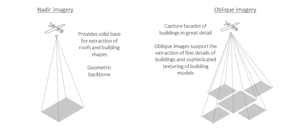
Oblique images are taken with the camera pointing at an angle to the ground. This provides a wider view of the landscape, which can be useful for identifying features and objects that would be obscured in a nadir image.

Oblique imagery is often used in applications such as:

  • Architectural design
  • Urban planning
  • Land use analysis
  • Advertising

Comparison of Nadir and Oblique Imagery

SGN nadir vs oblique images e1706616376302

Conclusion

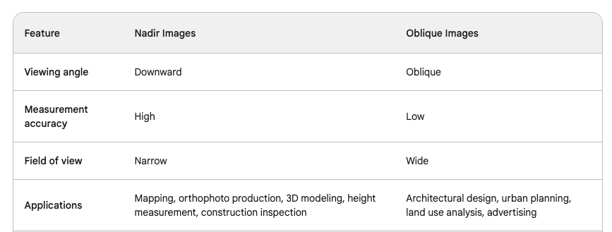
Nadir and oblique imagery are two different methods of aerial imaging that each have their own advantages and disadvantages. The best method for a particular application will depend on the specific needs of the user.

2022 06 27 SD 3D PV Banner
300x250 GeoWorld banners partners

Suggested Articles

Leave a Reply

Your email address will not be published. Required fields are marked *

Fill out this field
Fill out this field
Please enter a valid email address.
You need to agree with the terms to proceed