
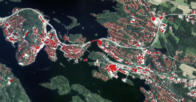
The National Land Survey of Finland (Maanmittauslaitos) has undertaken a pioneering initiative to utilize artificial intelligence (AI) in correcting inaccurate building location data across more than 1600 square kilometers within its extensive terrain database. This innovative approach, a part of ongoing AI model training, aims to automatically improve the precision of location data for buildings and water bodies within the database.
The demand for highly accurate location data, especially with the rise of autonomous driving, has driven the National Land Survey of Finland to focus on refining the precision of location data in its terrain database. This involves automating data collection processes and ensuring the timeliness of the data.
Lingli Zhu, the project manager at the National Land Survey, explains potential challenges in building location data, such as technical limitations, varying accuracy requirements over different periods, and potential human errors.
During the project, AI corrected building location data in 11 regions, including Kuopio, Savonlinna, Lahti, Vaala, Uusikaarlepyy, Uusikaupunki, Ylitornio, Parainen, Riihimäki, Jyväskylä, and Oulu. This correction process involved comparing the terrain database buildings with those identified by the AI and adjusting as necessary. The AI also aided in identifying missing and demolished buildings in the database.
While AI generally recognizes buildings effectively, challenges persist in densely forested areas. Improvements in identifying problematic buildings are anticipated, with plans to utilize lidar scanning data in the future.
Identifying water bodies poses different challenges for AI due to the varied nature of water features in the terrain. Ditches were the easiest to identify, with a high success rate in manual digitization. However, recognizing natural streams and ponds was more complex, hindered by factors like canopy cover and physical variability.
“AI-identified water bodies will help form a comprehensive network of waterways in the future,” says Zhu.
The terrain database serves as a unique, nationwide digital location data repository, widely utilized by municipalities and other organizations for various applications such as property taxes and addressing systems. The upcoming improvements will significantly enhance the quality of data in the terrain database, offering benefits across various fields.
“The future holds a significant reduction in manual work as the AI model gets trained with high-quality data, such as aerial images, covering all of Finland’s production areas,” Zhu anticipates. This initiative by the National Land Survey of Finland marks a significant step in harnessing AI to refine and maintain the quality of critical national data resources, setting a new standard in geospatial data management and application.


