
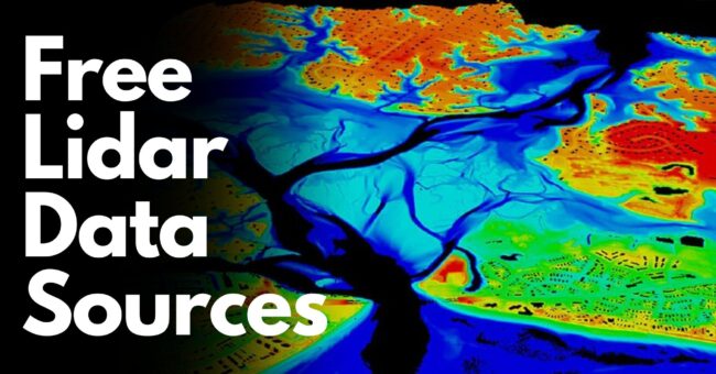
This is a comprehensive list of free LiDAR, DTM, DEM, and DSM data sources that will prove invaluable for various analyses, plans, and tests in your work.
Whether you’re a student, employer, engineer, or employee, these resources are tailored to meet your needs.
Let’s delve into the wealth of information they offer.
The best part?
All of these free lidar data sources work GREAT in 2024.
Let’s get started…

Provides free LiDAR data for coastal areas in the United States.
Supports coastal management projects.

Brings together geographical resources in the United States.
Provides comprehensive data sets for land use planning, natural resource management, and environmental protection.

Provides access to open data sources across Europe.
Offers a valuable resource for researchers, developers, and policymakers.

Collects, processes, and distributes high-resolution geospatial data.
Provides a valuable resource for researchers and scientists.

Manages land and property data in Finland.
Supports land registration, land use planning, and geographic information system (GIS) services for the Finnish government and citizens.

Provides surface modeling and elevation data for Switzerland.
Offers detailed geographic data used for land planning, construction, and environmental analysis.

Manages land information in New Zealand.
Provides property records, geospatial datasets, and mapping services, meeting New Zealand’s geographic information needs.

The Scottish Lidar Remote Sensing Portal provides a comprehensive platform for discovering, accessing, and analyzing remote sensing data collected over Scotland. It is a valuable resource for researchers, planners, and policymakers involved in various environmental and geographical projects across the region.

Kartverket Høydedata offers topographic elevation data for Norway, catering to a wide range of applications including terrain analysis, disaster risk management, urban planning, and natural resource management. This dataset is instrumental in understanding and managing Norway’s diverse landscape and geographical features.

Agencija rs Za Okolje is Slovenia’s environmental information management agency responsible for collecting, analyzing, and disseminating data on water quality, air pollution, climate change, and nature conservation. The agency’s datasets play a crucial role in environmental monitoring, policy-making, and scientific research efforts in Slovenia.

LiDAR British Columbia offers LiDAR data for the province of British Columbia, Canada. This dataset is widely used for terrain modeling, land use planning, forestry management, infrastructure development, and environmental assessment projects. It provides valuable insights into the diverse landscape and natural resources of British Columbia.

ELVIS (Environmental Land and Visual Information System) provides GIS and mapping services for local governments and public agencies in New Zealand. It supports the development of map-based decision support systems, land management strategies, environmental assessments, and infrastructure planning initiatives across the country.

Forêt ouverte is a valuable resource for forest data and resources in Quebec, Canada. It offers comprehensive datasets for forestry management, land use planning, biodiversity conservation, and ecological research specific to the Quebec region. The platform provides access to detailed information on forest ecosystems, tree species distribution, and habitat mapping.

The Canadian GIS Database is a centralized repository for GIS data in Canada, offering a wide range of geospatial datasets for land use planning, environmental monitoring, infrastructure development, and natural resource management. The database facilitates access to authoritative and up-to-date spatial information for decision-making and research purposes.

Datafordeler is an open data platform in Denmark that aggregates various data sources from the public and private sectors. It provides access to a diverse range of geospatial datasets, including land use data, demographic information, transportation networks, and environmental data. The platform promotes data sharing, collaboration, and innovation in Denmark’s spatial data infrastructure.

Estonia Land Board Spatial Data offers GIS data services in Estonia, providing mapping services, geospatial datasets, and satellite imagery for a wide range of applications. The platform supports urban planning, environmental monitoring, agriculture, infrastructure development, and disaster management efforts in Estonia.

Provides Lidar data for the Guadalajara, Mexico area.
This data can be used in a variety of applications such as terrain modeling, infrastructure planning, and environmental analysis.

Lýsigagnagátt is a division of the National Land Survey of Iceland, responsible for geographic data and mapping services in Iceland.
These data can be used in a variety of applications such as geographic information systems (GIS), land planning, and tourism management.

IGN (National Institute of Geographic and Forest Information) is a map portal operated by France’s leading geographical and forest information institution.
This portal provides access to various geographical data of France and offers users comprehensive mapping services, giving access to information such as land use, transportation network, topographic details, and other geographical features.

High-Speed Broadband Map is a resource providing high-speed broadband map data in Ireland.
This resource provides detailed data on broadband internet access in Ireland and provides information on the state of the internet infrastructure.
The resources listed here are designed to streamline the work of professionals and students across various sectors.
Offering free access, these data sources will greatly assist you in your analyses, plans, and tests.
So those are my free Lidar data sources.
And now I’d like to hear from you:
Are there any others that you love… but didn’t see on this list?
Or maybe you have a question.
Either way, let me know by leaving a comment below right now.


