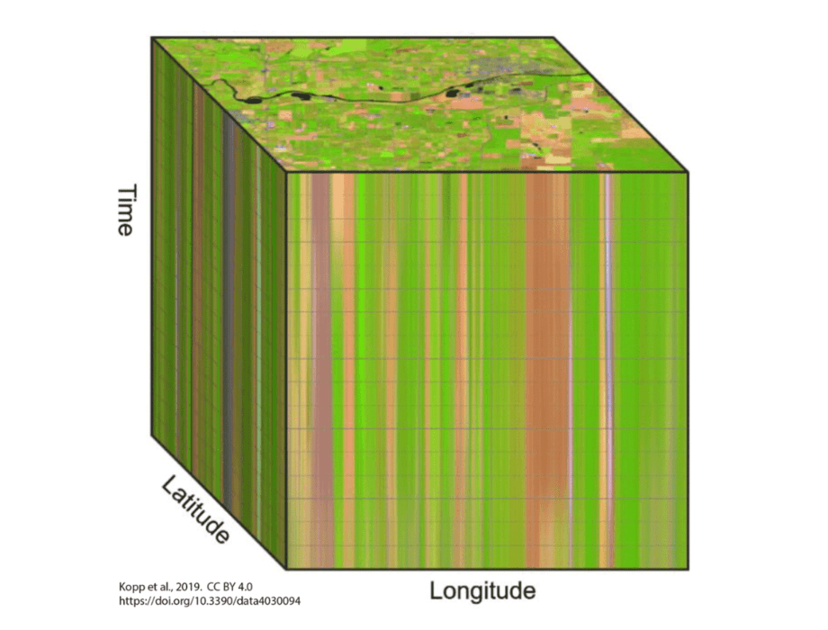
Datacubes (or data cubes) are a form of data structure, where data are stored in multidimensional arrays (n-D arrays); the data contain one or more spatial or temporal dimensions. Datacubes provide an effective way to apply analysis on spatiotemporal data, where data incorporate both raster and vector data along with potentially other information.
One way to think of this is as data that represent specific regions or areas, as one possibility, but with added timestamps, with different data formats combined. Data do not need to be represented in a specified dimension, but they are placed in varied dimensions, with the shape and arrangement of data designed for a project or application.
Datacubes typically have dimensions with given properties common to different formats of spatial data. Typical properties include name, axis/number, type of data, extent/nominal dimension labels, reference system or projection, and resolution.
In terms of application, datacubes provide a lot of benefits for a variety of analyses. These properties are stored as either numbers or strings (i.e., text) data. Additional data, such as the CRS or sensor information, can be turned into a dimension attribute. Data are stored as scalar as well as dimensions.
Increasingly, Earth observation (EO) data are stored as datacubes, helping to assist the analytical process. In particular, as satellite data often deal with temporal attributes, datacubes make an ideal way in which data are stored and processed for different analyses, including in machine learning algorithms or statistical procedures operating matrix algebraic equations.
Multiple satellite data types and temporal datasets can be stored within datacubes for given regions. Increasingly, we are seeing datacubes also applied in cloud-based systems, making the storage, distribution, and association of related data easier since datacubes can combine spatial and temporal information. This has the benefit of grouping analyses together, where data are bundled and applied in distributed forms of calculations for larger datasets.
A benefit of datacubes is they enable easier updates and modification to existing regional data. Increasingly, programmes, called spatial online analytical processing (SOAP), are being developed to process and deploy datacubes for dynamic maps and even charts and tables containing useful information about given imagery.
Additionally, SOAP-based programs can be created to handle data at a meta-level, where data storage, as well as handling data sets, are controlled by the software. In effect, this makes datacubes efficient both as a data model for analysis as well as a storage tool to facilitate the display of information.
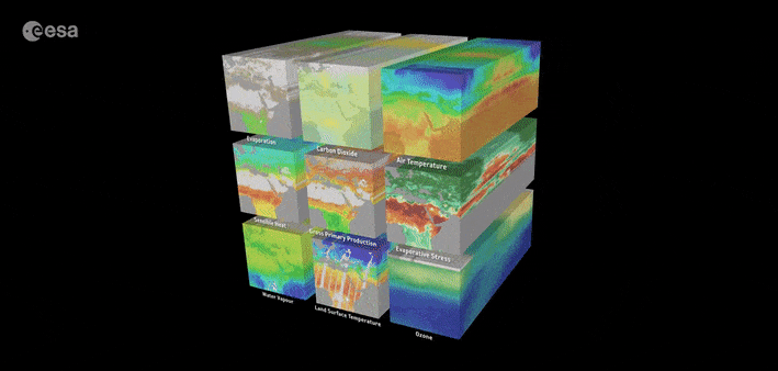
What is also useful about datacubes is they can combine all types of information, targeting spatial and temporal data for different domains. For instance, if data are collected about habitats and different biological species, such information can be wrapped along with the spatial and temporal dimensions. This provides automated and analytical ways to update information about maps of interest. For instance, varied habitat changes can be easily mapped over time.
The intent of datacubes is to facilitate data transfer, analysis, and storage. GIS systems are taking advantage of datacube formats. We are seeing the application of datacubes today to a variety of tools, while both open and proprietary formats are available.
One of the benefits of datacubes is not they only help to make dynamic mapping easier, but datacubes could be a key way for data interoperability. For instance, information from different satellites stored in datacube dimensions could make it easier to share information containing different EO data. Particularly for EO, datacubes have become a key way users interact with large datasets containing varied imagery.
Furthermore, datacubes are applicable for all types of information, enabling non-spatial data to be integrated as part of data sharing and analysis. With varied data sources, including satellite, UAV, and other spatial data increasingly made available, we may expect that datacubes could be among the most common way to integrate and utilised such data together for large, analytical projects and where large datasets are needed for dynamic mapping and analysis.
Source: Datacubes in GIS