Discover the latest breakthrough in underwater lidar technology that is revolutionizing seafloor mapping. With a focus on high-resolution and detail, researchers at the Monterey Bay Aquarium Research Institute (MBARI) have partnered with 3D at Depth to develop cutting-edge subsea lidar technology. This collaboration aims to unlock the mysteries of the ocean floor by generating remarkable, detailed maps of underwater features. Join us as we explore how these advancements are reshaping our understanding of ocean ecosystems and the importance of seafloor mapping for scientific research .
Discover why high-resolution seafloor mapping is crucial for understanding the complex terrains and ecosystems of the deep sea. Explore the urgent need to expand our knowledge to preserve these delicated habitats amidst challenges such as climate change, pollution, and overfishing.
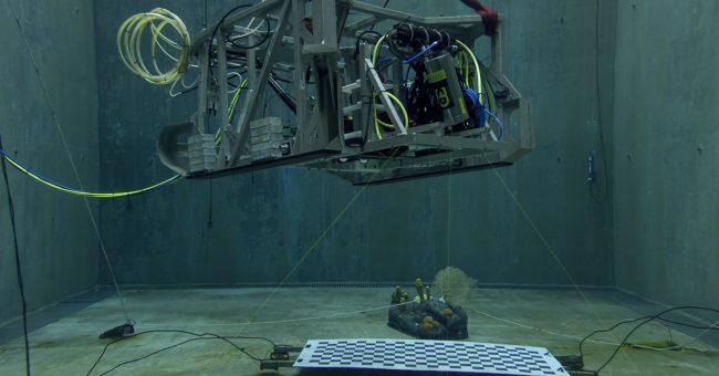
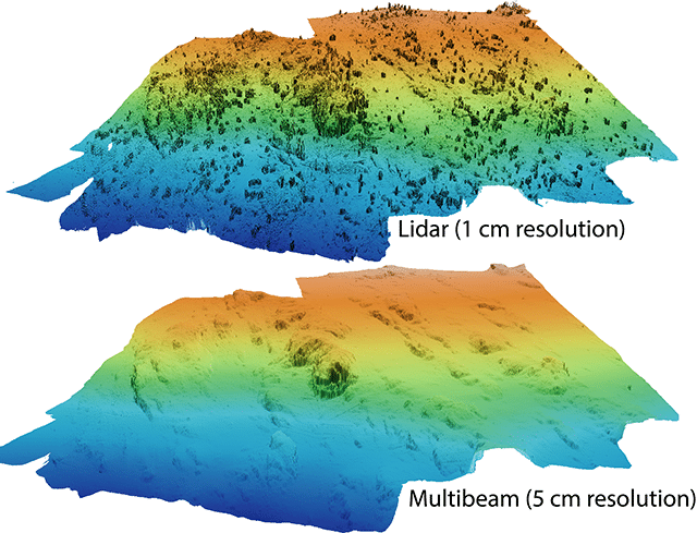
Delve into the evolution f lidar technology and its role in transforming seafloor mapping. Learn about the extensive collaboration between MBARI and 3D at Depth, showcasing advancements made through lidar integration on autonomous underwater vehicles (AUVs) and remotely operated vehicles (ROVs ). Understand the advantages of lidar over traditional multibeam sonar and its ability to capture fine details with exceptional resolution.
Explore the game-changing features of the Wide Swath Subsea Lidar (WiSSL), the latest innovation in seafloor mapping. Discover how WiSSL builds upon previous lidar systems, with enhancements such as a wider field of view, increased depth rating, portability, and reduced power consumption. Learn how these improvements facilitate integration with autonomous platforms, enabling scalable seafloor mapping efforts.
Uncover the transformative capabilities of the next-generation WiSSL system, offering a 360-degree field of view and three-dimensional scanning capabilities in various environments. Understand the implications of these advancements, including the ability to study open water, complex terrain, and vertical surfaces. Explore the wider applications of lidar technology in underwater exploration beyond seafloor mapping .
Highlight the critical role of seafloor mapping in advancing scientific research and conservation initiatives. Learn how detailed maps facilitate the understanding of seafloor geology, identification of methane gas seeps, mapping of fault lines, and study of deep-sea coral and sponge communities. Emphasize the importance of repeated mapping to monitor changes and preserve vital habitats.
Witness the transformative power of next-generation underwater lidar technology in revolutionizing seafloor mapping. The collaboration between MBARI and 3D at Depth is unlocking the secrets of the ocean floor with unprecedented resolution and detail. These advancements will contribute to our understanding of ocean biodiversity, ecological functions, and the potential impacts of human activities. Seafloor mapping plays a vital role in guiding conservation efforts and ensuring the long-term sustainability of our planet’s largest and least explored ecosystem.
Source, https://www.mbari.org/